This particular hike into Shutol was the best that I've been on since I got here, and quite possibly ever in my life. It was the type of experience where I had the profound feeling of being in the middle of something that I would probably never get to do again. I get that feeling on a semi-regular basis around here, but it was particularly strong on this hike.
The intention of the hike was to do a flood damage assessment, since our previous hike into the same area had concluded with the biggest flood anybody had ever seen. We went in along the floor of the valley, traveling through several villages before arriving in Roydara, which is tucked back into a side valley that feels quite remote, even though as the pictures will show, it's only one ridgeline over from one of the most populated areas in the entire Panjshir Valley.
Once we got to Roydara, we stopped and had lunch with the locals, who suggested that we hike out along the ridgeline, since it would be "about an hour" faster than going out the same way we came in. This turned out to be standard Afghan time-telling. An accurate sense of time - accurate for a watch-carrying American - is not something you're likely to find around here. On most of our hikes, when the fat, slow, and lazy American asks how much farther it is, the lean, quick, 70-year-old Afghan answer is generally "ten or fifteen minutes", which usually works out to about an hour. The estimate that the hike out would save an hour wasn't entirely wrong, since the trip out might have been slightly faster, but what he neglected to tell us was that we would have to climb 2400 vertical feet in just under a mile and basically go straight up the mountain outside of his house.
That's when the hike got really interesting, because we just kept going up, and up, and up, and then all the sudden we got to this view, and all the pain went away:

Then a little farther down the ridge we got here.

It's not quite as edge-of-the-world as it might appear, but it was still an incredible view. The haze obscures the plains in the distance a little bit, but what you're looking at is the outside of the valley, towards Parwan and Kapisa, two neighboring provinces. Here's another one, only with us facing the camera this time. From left to right, it's the senior NCO for our civil affairs team, my boss (the chief engineer), me, and our Physician's Assistant, who goes by Doc.

This next one is looking back down into the valley that we hiked into. The village is called Sange Lakhshan, and it has obviously experienced some flooding in the past, because everything is built up high enough to have prevented any homes from being washed away during the most recent flood. They lost a significant amount of farmland, but that goes for nearly the entire valley.

This one looks north through the main valley, similar to the first picture, only with a broader perspective.

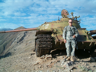
Finally, I'll wrap this up with what I suspect was an Afghan message to the Russians. This tank is in the single most unlikely location I can possibly imagine, although I don't have a good picture of it from a distance. If you can't tell from this one, it's perched on top of one of the highest peaks in the area. I have no idea how they got it there, but it couldn't have been uplifting to retreat from a region as the enemy was dragging (or driving) your heaviest piece of equipment onto the tallest mountain in the area. It's not the greatest picture of me, but it should give you some idea of the location.

No comments:
Post a Comment